


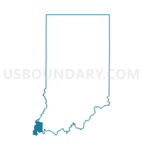
BLACK 01, Posey County, Indiana
About
Outline

Summary
| Unique Area Identifier | 580200 |
| Name | BLACK 01 |
| County | Posey County |
| State | Indiana |
| Area (square miles) | 14.62 |
| Land Area (square miles) | 14.59 |
| Water Area (square miles) | 0.03 |
| % of Land Area | 99.77 |
| % of Water Area | 0.23 |
| Latitude of the Internal Point | 37.98931920 |
| Longtitude of the Internal Point | -87.85523780 |
Maps


Graphs
Select a template below for downloading or customizing gragh for BLACK 01, Posey County, Indiana


Neighbors
Neighoring Voting District (by Name) Neighboring Voting District on the Map
- BLACK 02, Posey County, IN
- BLACK 03, Posey County, IN
- BLACK 04, Posey County, IN
- LYNN EAST, Posey County, IN
- MARRS NORTH, Posey County, IN
Top 10 Neighboring County Subdivision (by Population) Neighboring County Subdivision on the Map
- Black township, Posey County, IN (9,450)
- Marrs township, Posey County, IN (5,177)
- Lynn township, Posey County, IN (895)
Top 10 Neighboring Unified School District (by Population) Neighboring Unified School District on the Map
Top 10 Neighboring State Legislative District Lower Chamber (by Population) Neighboring State Legislative District Lower Chamber on the Map
Top 10 Neighboring State Legislative District Upper Chamber (by Population) Neighboring State Legislative District Upper Chamber on the Map
Top 10 Neighboring 111th Congressional District (by Population) Neighboring 111th Congressional District on the Map
Top 10 Neighboring Census Tract (by Population) Neighboring Census Tract on the Map
- Census Tract 404, Posey County, IN (5,646)
- Census Tract 406, Posey County, IN (3,474)
- Census Tract 405, Posey County, IN (3,317)
- Census Tract 402, Posey County, IN (2,341)